SailGrib
Sailing Apps
Marine wheather, Routing
Tides, Currents
Chartplotter, AIS, NMEA
Anchor alarm
Regatta start
The most highly rated sailing apps on the Android Play Store: weather, tides, currents, routing, nautical charts, NMEA, AIS, anchor alarm and much more…
You can install the apps on your Android phone or tablet or even both, then: download and view marine weather, calculate the tide, optimize your route, buy, download and view nautical charts, track your navigation with AIS and NMEA modules, monitor your mooring and finally take first class regatta starts.
Purchase a license and use the apps on all your Android devices registered with the same Gmail account.
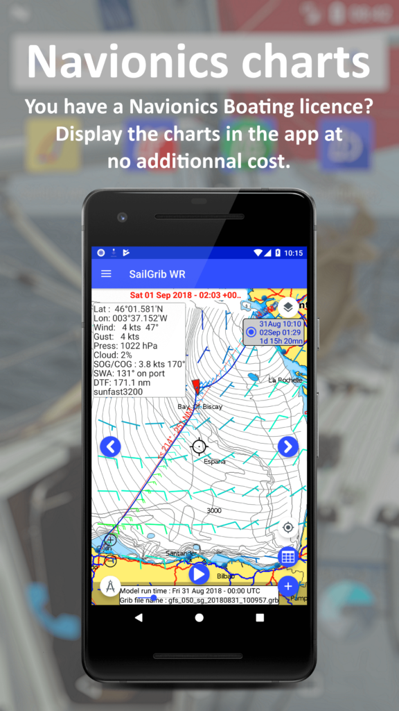
New: Do you have a Navionics Boating license? Use your charts in SailGrib WR at no extra cost!

SailGrib WR, our flagship app, includes all the features you will need to navigate: weather, tides, currents, easy to use but very powerful routing, NMEA, AIS with its alarms. You can use your Navionics charts, or purchase atlases of marine charts as in-app purchase.
SailGrib, our weather and tide app: download and display grib files from many different sources (NOAA, Météo France, Météo Consult, Great Circle, Open WRF, Open Skiron, Mercator Ocean for tidal currents, GMN, …) and calculate tides for the world’s major harbours.
With SailGrib AA, our anchor alarm application, your boat’s position will be permanently monitored. In case of a confirmed alarm, an alarm will sound and you will receive an SMS. Leave a phone plugged into your boat and you have a burglar alarm!
With SailGrib RS, our regatta start app with a very simple design, you will know in real time where you are positioned with regards to the line and whether you are ahead or behind to the regatta start.
Features That Matter
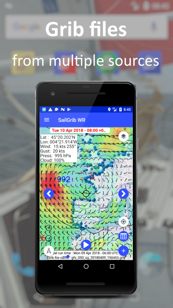
Multiple weather sources
Do not take just one source of Weather for granted. SailGrib can download grib files from many organizationsMultiple weather sources
like the NOAA, Météo France, Great-Circle, Météo Consult, Mercator Ocean (oceanic and tidal current), Open WRF, Open Skiron, GMN…
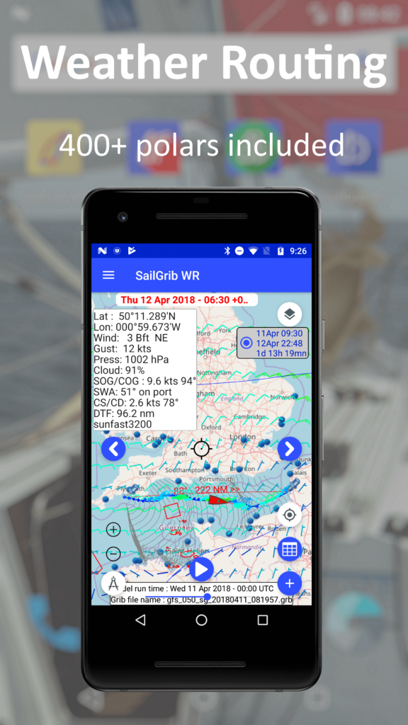
Unique Weather Routing
SailGrib WR router optimizes the route for you in a simple way that hides a powerful algorithm. The end result is a...Unique Weather Routing
faster, more comfortable, more predictable and in the end a safer sailing trip.
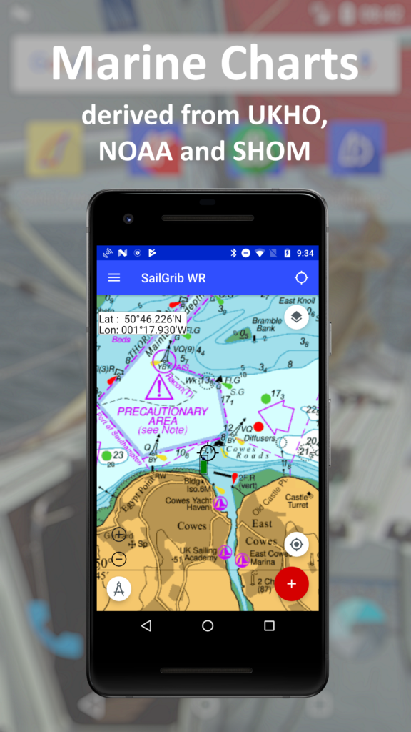
Marine charts
Use your already purchased Navionics charts.Marine charts
Download for free the NOAA raster charts or buy atlases of charts derived from the UKHO and the SHOM. You can as also make your own MBTiles charts.
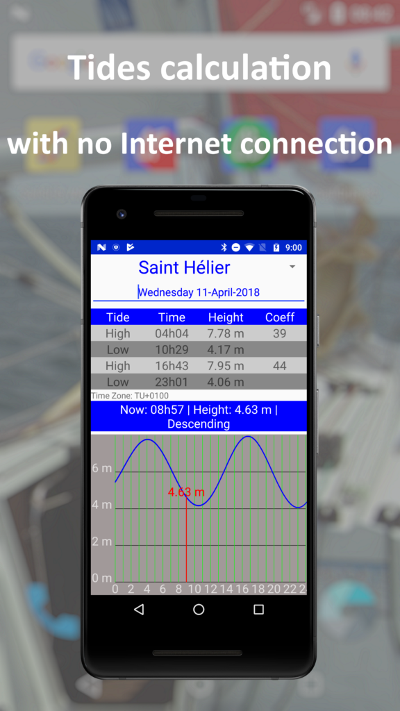
Tides Calculation
SailGrib calculates tides for most of the main ports in the World. No internet connection is needed.Tides Calculation
Tides are displayed directly on the charts, click anywhere to get detailed data for the closest station.Atlases of tidal currents
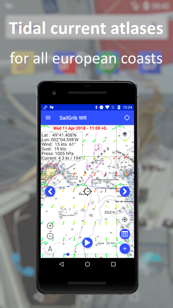
Atlases of Tidal Currents are provided for all European coasts. A SailGrib exclusive!Atlases of tidal currents
Computed by us from Mercator Ocean data, atlases are preloaded in the app. Activate them, you are all set. No grib needed!Certified by Iridium
Designed for Iridium GO! and approved by Iridium - SailGrib is the only marine app in the Android Play Store that is certified by Iridium.Certified by Iridium
Get an Iridium Go, download the Iridium app on the Play Store and cross the oceans with SailGrib!Run on a Chromebook
Run the apps on Google Play Store compatible Chromebooks.Run on a Chromebook
Chromebooks do not have a GPS, use the one from your NMEA feed.
Data Sharing
Transfer grib files easily to your computer. Read them with OpenCPN, Maxsea, Expedition, Adrena...Data Sharing
Routes and routings are saved in KML formats: import your routes from Navionics, export your routings in OpenCPN, Google Earth…
Very Affordable
SailGrib apps are very affordable. They cost a fraction of the equivalent PC software if they exist!Very Affordable
Use your SailGrib apps on your phone and tablet with one license only.
Testimonials
It’s great to have access to all these quality files on a cell phone!
While cruising, for my marine weather forecast and my weather routing, I use SailGrib WR.

Recently I used the app with Ragamuffin.
The next time will be the volcano race in Capri in may.
App is very good.
Thanks again

Sailgrib WR is a detailed, well thought out and information loaded app offering incredible value for money to any sailor looking at weather routing. The app has clearly been designed by a sailor and incorporates all of the key functions you would expect from a desktop weather routing program, with extensive forecast models available, a large range of polars and incredibly a European inbuilt tidal atlas included in the price.The menus are well thought out and easy to use, results and data are visually presented using colour and good lay to help with understanding, the app is responsive and fast to produce a good quality weather routing option.
This is a bargain but quality product for any sailor racing or cruising.

“Impressive” – Yachting World – July 2014

Congratulations to SailGrib which allowed us to be well prepared for this Fastnet. We downloaded for free the high resolution Arpège and Arome grib files from Météo France. Thanks to the visit of the Plymouth Bay that the Arome routing showed us, we managed to get to Lizard Point in a great position.

Awesome – The only app that can be do Weather Routing, read grib files from many sources and, in addition, take the current into account. The choice between the various grib file providers is unique. Which other gribs file viewer allows you to pick your provider and draw meteogram? As for the routing, this is the best. A MUST HAVE app.
A great tool! Simplifies routing – unbelievable !!! In fact, a 10 star value!
Weather routing supreme. This app has clearly been built by someone who knows their sailing and is full of marvelous features. More intuitive than anything else out there, I have found it indespensible when making ocean crossings and coastal trips in big races. I eagerly await each new version to see what clever feature has been added and for the price having this valuable app in your navigation toolkit is a no- brainer.
On account of this app, most of my friends with iOS lament that they don’t quite have the best tool for the job.
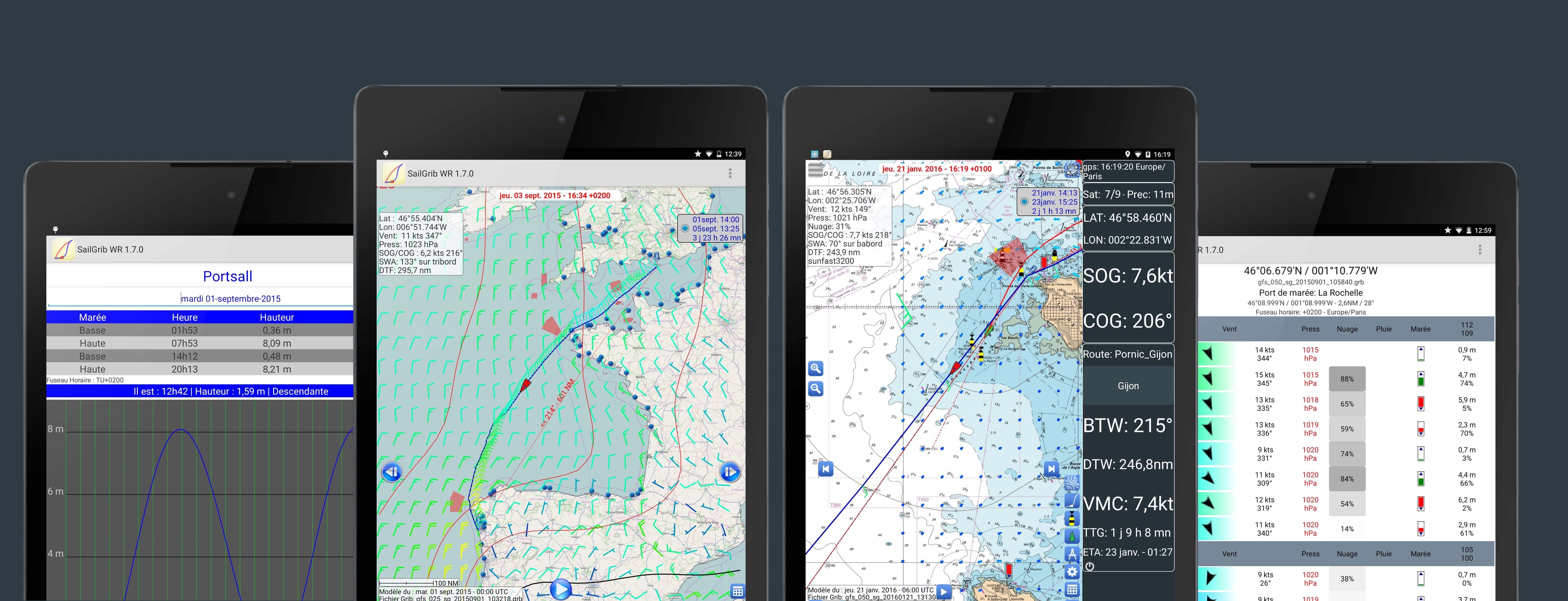
Screenshots
YouTube
Clock here if you can’t watch our YouTube playlist.
 S'abonner à la chaîne
Who Are We
Philosophy We Strive For
We strive to create apps that facilitate the preparation of your sailing trips or races. Our goal is that, once at sea, you can sail better, faster and safer.
We seek to make effective no-frills apps.
As Marine Weather Forecast is the basis of every good preparation, we started by publishing SailGrib: an app that allows you to get weather grib files from different sources while on earth or at sea. We then added a tidal module such that with a glance, you get the essential parameters of your sailing trip.
A Weather Routing software is an incredible tool to optimize sailing routes for the safety of navigation. These software were unfortunately unreachable to sailors for many reasons: cost, lack of polar diagrams, complicated user interface … We’ve simplified it all by creating an app where everything is included – weather, polars, tidal currents – and is still simple to use!
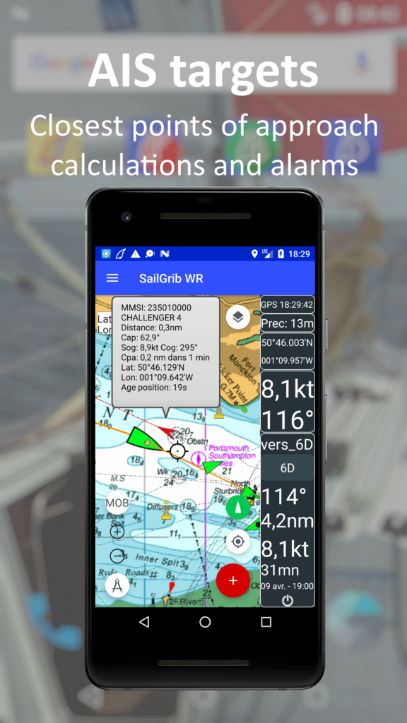
The next step was to add Navigation modules. We added an NMEA 0183 and an AIS interface. Real time performance data are now calculated, AIS targets are displayed and an alarm is raised in case of danger.
Finally, we added marine charts: you can download for free NOAA raster charts or buy, as in app purchase, atlases of marine charts derived from UKHO or SHOM data;
We are proud of the accomplishment and the feedback from our growing user community pushes us to continue the development of the apps…
Skills We Use

Henri Laurent
I have been sailing since the age of 5 on pretty much anything that floats. Graduated from a top French University, I spent 15 years in the United States in the financial industry. I sailed the 2012 Transquadra, a two handed transatlantic race on my Sun Fast 3200 “Coeur de Chauffe 3”.
The idea of creating SailGrib germinated during the preparation of this transatlantic race: it was a shame to have a “smartphone” that could not download a grib file in a simple way. Building a Weather Routing app was the next challenge. Making a full-fledged navigation app, the final goal.

Get In Touch With Us
Send us an email: henri@sailgrib.com
Stay tuned and receive the SailGrib newsletter.
Download SailGrib Apps Today!
SailGrib WR
All the modern navigation tools.
grib files
– tidal prediction for most of the major harbors in the world.
– navigation module
– renowned weather routing with more than 400 polars
– Navionics charts integration: you have a Navionics license, use your charts in the app
– in app purchase of SHOM and UKHO based atlases of raster marine charts
– free download of all NOAA marine raster charts
– acquisition and display of surface pressure charts (NOAA and MetOffice)
– atlases of tidal currents for all European coasts
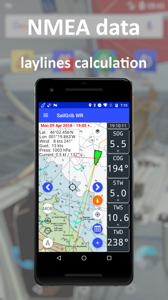
– NMEA data
– AIS with alarms
The free version is limited to:
– 48 hours of weather forecast
– GFS 0.50° model
– one day tide
– 50 NM routing
by Ralph Lechterbeck.
Thanks!
You someone write my essay might also wish to work with a scratch pad using the paper so you can jot down important items and save the rest for later.
SailGrib
Grib files from the NOAA, Metéo France, Great Circle, Météo consult, My Ocean, Open Skyron, GMN,..
Tidal prediction for most of the major harbors in the world.

SailGrib AA
Anchor alarm:
– record your track on a map.
– Wetting zone defined in a fraction of a second.
– Audible and SMS alarm in case of confirmed alarm.
– Very low battery consumption
SailGrib RS
Regatta start:
– point the committee boat and the end of line buoy
– wind is initialized with the GFS model
– distance to the line and favored side
– regatta chronometer
– burning time
– simple design


